

Theme 2: Public health, epidemiology, and environmental justice
Theme area 2 research will be led by Dr. Tarik Benmarhnia and will aim to answer the broad question: What are the locally-specific health impacts of extreme heat, and how do they vary according to land use and socioeconomic factors?
Extreme temperatures have substantial public health burdens with risks ranging from heat exhaustion to death. Furthermore, the substantial burden associated with extreme heat is not equally distributed across subgroups of the population and communities. In our previous work, we showed how different individual (e.g., age, ethnicity, income) and contextual (e.g., urban design) characteristics modify the risk associated with extreme heat. In this project, we will integrate an environmental justice framework to consider differential vulnerability to extreme heat among coastal Southern California communities. Impacts to public health caused by extreme heat are known to be non-random and intersect with other social determinants of health. Considering such environmental justice issues will be critical to explaining and quantifying the reported differential impacts of extreme heat across heterogeneous communities, as well as for devising effective intervention strategies.
Research Objectives:
- Assess the small-scale spatial variability in heat-health impacts across a multitude of heat conditions.
- Quantify the contribution of atmosphere-land-ocean factors in modifying spatio- temporal patterns in heat-health impacts.
- Quantify the contribution of environmental justice metrics in explaining spatio- temporal patterns in heat-health impacts.
- Model the role of green space indicators in modulating spatio-temporal patterns in heat- health impacts.
- Simulating scenarios for increasing green space & health impact assessment
Research Questions:
- What is the number of hospitalizations attributable to a large set of heat conditions for each zip code that could be prevented via effective adaptation strategies (e.g., better prediction and differentiation of heat waves, advance warnings, urban greening, community engagement)?
- Which atmosphere-land-ocean factors contribute to explaining the variability in the number of hospitalizations attributable to a large set of heat conditions for each zip code?
- Which environmental justice metrics contribute to explaining the spatial variability in the amplitude of the burden associated with the large set of considered heat conditions?
- How, and to what extent, does the spatial variability in various green space indicators explain the spatial variability in heat-related impacts?
- What could be the benefits of various greening strategies in reducing the spatial inequalities in heat-related impacts in San Diego?
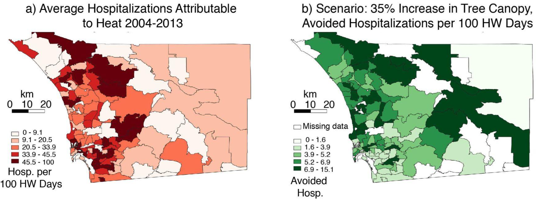
a) Average hospitalizations attributable to heat by zip code for San Diego County. b) Total benefits of one greening scenario (increase tree canopy by 35%) in terms of avoided hospitalizations per 100 heat wave (HW) days, defined as days where maximum daily air temperatures exceeded the 95th percentile. Hospitalization and tree canopy data are from OSHPD and the California Healthy Places Index, respectively.